All Things Weather

weather-related:

The NFL is officially moving the game between Buffalo and Cleveland to Ford Field in Detroit, where it will be played at 1:00pm on Sunday.

Buffalo is playing the Lions on Thanksgiving day, so the Bills will play two games in Detroit next week.

(a week in Detroit for Bills fans....I hope the liquor stores are well-stocked......)...............
By Sunday the weather will be just fine but I imagine getting the stadium ready and the teams getting to the stadium would be difficult. If they were playing in Buffalo it would probably be with no fans anyways, otherwise it would be a disaster with 70K people trying to get to the stadium.


The Orchard Park totals are in about 14-15 hours. Almost 3 inch per hour over half a day. It continues today.


If we got that much snow, I might have to give up on the plastic shovel and buy a snow-blower.


Report of 66” in Orchard Park where the stadium is.


Weather question for you @GopherWeatherGuy - how do they actually measure the inches of snow that falls when there's also a lot of blowing wind? Measure it along a snow fence and it'll be really deep - measure it in the middle of an open field where the wind is blowing and it'll be much less. Even in my driveway there's a big variation in the depth of snow that happens from a storm.

I don't have much to add to what GII and SON posted. I try to find the best open area that may have some sort of distant wind break to help shelter it a little.

I think the best is to take an average of the area, compare that to the melted liquid and calculated snow ratio's. That should give you a pretty accurate reading. But measuring snow with strong wind is still an imperfect Science.


I'll be thinking of y'all up there in the cold and dicking with snow (potentially) while I'm getting in 45 miles on the bike this afternoon before the Gophers-Iowa game


Seems like we're in a quiet pattern here in the upper midwest. I want some snow before Christmas at least.


Seems like we're in a quiet pattern here in the upper midwest. I want some snow before Christmas at least.

It looked like this was going to be an active week last week, and it made sense as both the AO and NAO went negative and that's typically a good thing for an active/snowy pattern in December.

However the models have been really inconsistent beyond 4 days and a few of the storms just disappeared. But things are starting to look more active again later this week into next.

I will be surprised if there are not a few heavy snow producing storms between now and Christmas.
 

Those where it's cold enough could end up with a pile of snow next week. Probably mostly rain for me here in Wisconsin. My parents look pretty good in the Alexandria area at this point.

1670608158645.png
 

Weather question for you @GopherWeatherGuy - how do they actually measure the inches of snow that falls when there's also a lot of blowing wind? Measure it along a snow fence and it'll be really deep - measure it in the middle of an open field where the wind is blowing and it'll be much less. Even in my driveway there's a big variation in the depth of snow that happens from a storm.

Like GWG said sometimes it's just a best guess. Here is a video that explains how observers are supposed to do it.


Thanks, exactly what I'm looking for.

My wife makes fun of me for being a weather nerd (a very amateur one at that). I have no background in anything related to weather, just something I've always been interested in. I especially like the lead up to winter storms.
I have been interested in weather my whole life. When I was about 5 we had 4 big storms come through (one of them was this one: https://en.wikipedia.org/wiki/Western_Wisconsin_Derecho) and I think that got me kickstarted. I saw my first tornado when I was 9.

I've been a storm spotter since 2007. My claim to fame was that I reported the first tornado of this outbreak in 2009:


It was NOT a day tornadoes were expected, as it was in the middle of a huge shield of moderate rain, there was no tornado watch, and I believe there was not even any lightning present. There was however a 2% tornado risk, so there was plenty of spin in the air, and there ended up being 6 small tornadoes across the metro.


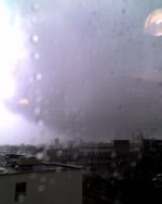
I was working in South Minneapolis that day, and my boss (whose cube was right next to the window) told me to come and look at the clouds. As I approached the window, what looked like fog was moving really quickly from left to right. I was 5 stories up so I had a great view, and once I surveyed what was going on, a clear as day tornado was visible about 4 blocks to my west right over the intersection of Lake St & Park Ave.

I immediately phoned it in to the NWS and they absolutely did not believe me. They didn't say so, but you could sense the skepticism. After the storm passed I went back to my desk and flipped the radar over to velocity and you could see the smallest hint of rotation right over where I was, so I knew I was right. The storm was moving due north towards downtown Minneapolis.

Ten minutes later no warning had come out, then finally one did. The text said "The public reported a tornado in downtown Minneapolis....". So it was obvious by this point whoever took my call just discarded it. It's too bad too, because I was only about 2 years removed from my training, and everything just clicked in my head. The training had worked perfectly and I knew exactly what I was looking at.

All I had was a crappy 2009 flip phone camera, but here is the picture I got it of it. This is from Lake St. looking NW, so towards about 35W & 26th St. The photo was taken at exactly 2:00 pm.
 

Attachments

  • tornado.jpg
    tornado.jpg
    23.5 KB · Views: 1

Getting ready for a few fun days in SW MN, NW IA and SE SD.

big system moving in. depending on the track and the air temperature, it's going to be a mix of rain, freezing rain, sleet and snow.

SW MN looks like we're going to get a lot of freezing rain during the day on Tuesday, then some on-and-off rain/snow/sleet/freezing rain stuff Wednesday and Thursday. the really heavy snow looks like it's going to hit SD.

went to Ace Hardware and bought two big jugs of ice melt. Hope it holds out.

back in 2013, the I-90 corridor got hit with a big Spring ice storm. lots of tree damage and power lines down. I hope we don't get that again.
How was the ice?
 

Looks like a big chill will be coming next week just in time for Christmas.


How was the ice?

didn't get as much as predicted - more of a mix of freezing rain, drizzle and sleet. I guess the rural roads got bad because they called off school on Tuesday. there was a lot more ice in the SW corner of the state - Pipestone really got nailed.

Wednesday got a little snow, then it snowed on and off all day Thursday into Friday. I shoveled twice, so maybe 5-6" total. then the winds kicked up and it started drifting, so another day with no school on Friday.

had to clean the sidewalk and driveway again Saturday from the drifting.
 

@GopherWeatherGuy not sure how much you're paying attention since it may not affect Minnesota as much as other parts in the midwest, but there continues to trend towards an all out blizzard in the midwest later this week. Models have trended more west today to put me in southern Wisconsin closer to the crosshairs. Snow, cold and extremely strong winds. Luckily we don't have to travel until Sunday. It'll still probably be rough due to the cold and strong winds but shouldn't be as bad as it will be a few days earlier.

Truly life threating situations in many places.


Top Bottom