BleedGopher
Well-known member
- Joined
- Nov 11, 2008
- Messages
- 64,166
- Reaction score
- 23,128
- Points
- 113
Go Gophers!!
@GopherWeatherGuy not sure how much you're paying attention since it may not affect Minnesota as much as other parts in the midwest, but there continues to trend towards an all out blizzard in the midwest later this week. Models have trended more west today to put me in southern Wisconsin closer to the crosshairs. Snow, cold and extremely strong winds. Luckily we don't have to travel until Sunday. It'll still probably be rough due to the cold and strong winds but shouldn't be as bad as it will be a few days earlier.
Truly life threating situations in many places.
Looks like the models are still disagreeing on who will get the most snow but yeah looks like it will be bad over a wide area. With 40+ winds, even 2 inches of snow can make it really bad. Then there's the cold with it as well.The blizzard will start in the Dakota's and Minnesota/Wisconsin Wed/Thu and shift eastward from there. I've already told most of my friends and family from SD - MN - WI not to plan on going anywhere Wednesday afternoon - Friday.
The Bills should probably fly there Wednesday.
Go Gophers!!
Looks like the models are still disagreeing on who will get the most snow but yeah looks like it will be bad over a wide area. With 40+ winds, even 2 inches of snow can make it really bad. Then there's the cold with it as well.
Wishful thinking. Was hoping for 12+ and a blizzard. Been forever since I've been through something like that. Still time for it to shift west.The Euro has been pretty consistent, and if people are looking at the GFS they should stop. It's trash. Pretty much the entire great lakes region north of the Ohio River valley is going to have issues through Saturday. The big cities on the east coast should remain mostly rain though.
Wishful thinking. Was hoping for 12+ and a blizzard. Been forever since I've been through something like that. Still time for it to shift west.

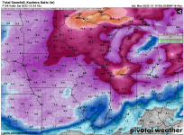
Is this amount of existing snowfall or new snow projected for 12/21-12/24?You may be in luck. Here's the latest snowfall totals from the Euro through noon Saturday. With the hills and the trees, it's really tough to get the wind to meet blizzard criteria, but it may be close.
View attachment 22580
Is this amount of existing snowfall or new snow projected for 12/21-12/24?
Are these maps always using 10:1 ratios? Would think the ratios would be higher, especially on Friday.New snow from now through noon Saturday. Most of it will fall Wed-Sat, although the Twin Cities will pick up a few inches today. The noon run just came out and looks very similar.
Are these maps always using 10:1 ratios? Would think the ratios would be higher, especially on Friday.
Depends on how old you are.I've lived in Minnesota my entire life and I don't think I've ever seen the landscape as beautiful as it is right now.
Here in southern Wisconsin we had some really wet heavy snow last week. There's still a lot of snow stuck to trees. And now it's frozen pretty solid to the trees. A little concerning that we could see some power outages with the strong winds. I'm going to load up on the wood just in case we need to get the fireplace up.
Here in southern Wisconsin we had some really wet heavy snow last week. There's still a lot of snow stuck to trees. And now it's frozen pretty solid to the trees. A little concerning that we could see some power outages with the strong winds. I'm going to load up on the wood just in case we need to get the fireplace up.

Many of those amounts eastern SD/Western MN are double what I'm seeing elsewhere. (3-4 vs 7-8). Is this adjusted because of the temperature?New snow from now through noon Saturday. Most of it will fall Wed-Sat, although the Twin Cities will pick up a few inches today. The noon run just came out and looks very similar.
Many of those amounts eastern SD/Western MN are double what I'm seeing elsewhere. (3-4 vs 7-8). Is this adjusted because of the temperature?
Unfortunately the models have decreased the snow totals quite a bit. I say that selfishly as lower totals is good for travelers.They're either wrongly using 10:1, or are being super conservative. Every model I've looked at is showing at least 6"+ for eastern SD - MN, some are going significantly higher.
Unfortunately the models have decreased the snow totals quite a bit. I say that selfishly as lower totals is good for travelers.
in my neck of the woods (Cottonwood County, MN)
NWS forecast is now calling for 6 to 7" of snow Wednesday through Friday.
the fun part is that winds are predicted for 25-30 mph on Thursday with gusts to 45mph. Talking whiteout conditions. if it gets that bad, out here in the flatlands, wouldn't be surprised to see road closings.
forecast calls for more snow as you move East across MN. I'm supposed to drive to SE MN on Saturday for family Christmas. That might be dicey.
hey, Weather guy - do you read or use the "scientific forecaster discussion" from the Natl Weather Service? I can understand a lot of it, but some of it gets too technical for my old head.
My wife will be extremely disappointed if we can't drive i94 to the TC on Thursday...I sincerely hope I'm not in the perpetual dog house for hiding the car keys to make sure she doesn't leave me and then drives around the i94 barriers.I do like to read the forecast discussions when I'm unsure and looking for another opinion, mainly on severe weather/tornado days.
Hwy 60 is going to be rough in your area the next few days. I've done that drive one too many times. But I'd bet both 60 and I90 will be shut down for at least some time Thu-Fri.
My wife will be extremely disappointed if we can't drive i94 to the TC on Thursday...I sincerely hope I'm not in the perpetual dog house for hiding the car keys to make sure she doesn't leave me and then drives around the i94 barriers.
Currently -9 air temp and snowing pretty good around St Cloud. Unusual to get these kinds of amounts in such cold temps.
