tikited
Me
- Joined
- Nov 20, 2008
- Messages
- 18,992
- Reaction score
- 6,250
- Points
- 113
Someone desperate for a cheeseburger is my guess.You took this?
Someone desperate for a cheeseburger is my guess.You took this?
You took this?
Sky donut
Seriously, no measurable snow in NYC this winter? Are golf courses open?Per NBC Nightly News last evening, the 157 January tornados thus fat are a record per the NWS.
NYC is just a week or do from the longest drought ever between measurable snowfalls -at 322 days.
Yes, zero.Seriously, no measurable snow in NYC this winter? Are golf courses open?
Could be a doozy next week.Let's just get this out there now that the "tournament snowstorm" legend is complete B.S. I already saw a Tweet about this regarding next week's potential storm.
This article explains it well, how it started as the "basketball" snowstorm (which used to only be boys, and there was some merit) and how over time it's morphed into the "tournament" snowstorm. Well since the tournaments are now 5 weeks long, of course you are going to have storms at some point in there.
Hopefully we will not have to take this post to the other OT board, haha!
Tournament Snowstorm Lore
www.dnr.state.mn.us
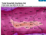
28"? Geeze.Could be a doozy next week.
28"? Geeze.

If you`re reading this discussion, then you are probably on the more
weather-savvy side compared to most people. And if you`re weather-
savvy, then you`re probably familiar with the ample weather sites
that show model data such as storm total snowfall accumulation. For
that reason, we figured it worth addressing the snow amount potential
in this discussion so here it goes.
From a probabilistic standpoint, some locations across the forecast
area have a greater than 50 percent chance of seeing at least 18
inches of snow over a 72hr window from Tuesday morning through
Thursday night. That`s incredible. The location will likely change,
so it`s not that important. What is important is that those
probabilities actually exist in the guidance, especially this far out
into the forecast. This lends some insight into the realistic totals
that we may see come Friday morning. Another noteworthy statistic is
that the lowest 5 percent of forecast (think low-end) still has
accumulating snow pretty much everywhere, and a heavier band of at
least several inches across the region. On the flip side, we won`t
dwell much on the 95 percent (think high-end), but it would indicate
that there is potential for some locations to see over two feet of
snow. Reality will likely fall somewhere in the middle, which is why
we don`t produce snowfall totals beyond 3 days into the future.
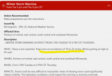
Bottom line is next weeks storm has a lot of potential to be the
extremely disruptive to travel, and could even cause some impacts to
infrastructure. In addition to what could realistically be over a
foot of snow, winds will be northeast at 20 to 30 mph, so blowing and
drifting snow will also be a concern. If this storm ends up on the
higher end of the forecast guidance, then the impacts could last into
Friday and beyond. Our official snowfall totals go out 72 hours,
which means we`ll start to capture this event in more detail early
next week. In the mean time, stay up to date on the latest forecast,
especially if you have travel plans.
The amazing thing about this forecast so far, is both the GFS And the Euro have been consistent now for 48+ hours, on about a 150-mile wide band of at least 12" (and up to 24"-30") of snow in central/southern MN. Every run today looks almost identical in terms of the 12+ amounts.
I can't imagine how this would actually happen but I guess we'll see.
View attachment 24040
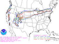
I spoke too soon.I don’t think I’ve ever seen this large of an area in the red in this graphic before.
View attachment 24080

Does this still look the same today? This is why I want to move.

I'm guessing any hope for golf courses opening in March is pretty much dashed.
Anywhere north or south of Dakota and Rice Counties would be just dandy.Would be sweet if the weather did that thing where it's impossible to model a dynamic system with 1 trillion variables, and so the blizzard actually ended up happening in some other place like Iowa.

